
More... history

Former Names for Lowestoft Streets, Roads and Scores
All of the older names listed below in italic font derive from documentation of one kind or another relating to the town – particularly those manorial records recording the transfer of property 1582-5 & 1616-1756, to the Revd. John Tanner’s transcriptions of these done up until 1720-25, and to the Manor Roll of 1618. All found as Suffolk Archives (Ipswich), 194/A10/4, 194/A10/ 5-19, 454/2 and 194/A10/73.


Historic England Building Listings: Additional Material
Lothingland Half-hundred
1. Ashby: St. Mary’s Church.
2. Belton: All Saints Church – Old Hall – Browston Hall.
3. Blundeston: St. Mary’s Church – The Rookery – The Pound – Blundeston House – The Plough inn.
4. Bradwell: St. Nicholas’s Church – Bradwell Hall – Hobland House.
5. Burgh Castle: St. Peter’s & St. Paul’s Church – Old Hall Farm – The Grange – Roman Shore Fort Gariannonum.
The Seven Commons of Lowestoft (14th-19th century)
One of the most interesting features of local landscapes during the Late Medieval and Early Modern periods in any community (and Lowestoft was no exception) was the presence of areas not used for agriculture – usually because the soil was unsuitable for crops or too difficult to work, for one reason or another – and being generally referred as either common or waste. The former term referred to the land being available to people for various kinds of use and the latter derived from the Latin word vastus, meaning “empty” or “open”.

Industries Related to Farming – 17th & 18th Century
Malting and brewing
Much of the barley grown in Lowestoft would have been used to make malt, the light soils in the parish producing the thin-skinned, mealy type of grain best suited for the malting process. Altogether, there were at least three or four separate malt-houses in different parts of town, which were in operation at one time or another during the Early Modern period and a similar number attached to the town’s breweries.

Interior Décor, Fittings and Possessions (Houses, 16th-18th Century)
Lowestoft Houses – 16th-18th Century
The most commonly mentioned items of interior decoration during the later part of the 16th century, in the houses of the merchants and the better-off tradespeople and craftsmen, are stained or painted canvas cloths. These served to decorate the walls on which they hung and they probably also served as draught-inhibitors. They were present in bedchambers, as well as in halls and parlours, but no indication is given as to whether they had scenes depicted upon them or whether they were simply covered in patterns.
 - Isaac Johnson")
Lowestoft Lighthouses (1609-1975)
Lowestoft’s “High Lighthouse” (as it was once known) had its origins back in the first half of the 17th century
Lowestoft Occupations (1561-1750)
One of the many interesting features to emerge from the study of Lowestoft’s history over the years, and the attempts to reconstruct aspects of its past arising from the evidence discovered, is the town’s occupational structure. As can be seen in the table below, the main source in all four fifty-year blocks is parish register material, followed by probate documentation (wills and inventories of goods & chattels), with various other sources following on and with the Tithe Accounts featuring strongly in the last sub-period of all.
 held by Suffolk Archives (acc. ref. no. 193/2/1).")
Outsider Presence in Lowestoft (1561-1730)
(Parish Register Entries)
The register entries below are presented in as close a way as possible to the original handwritten ones
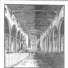
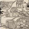
Photo opposite - The interior of St. Margaret’s Church in 1786 - historic repository of the Lowestoft parish registers - captured by Richard Powles (1763-1807). This ink-and-wash study is to be found in Isaac Gillingwater’s ‘Drawings Illustrative of the History of Lowestoft, Mutford and Lothingland’ (Suffolk Archives, Ipswich - ref. no.193/2/1).

Properties on West Side of High Street (1618)
(North of Mariners Street)
- Moving from North to South.
- Occupying former agricultural land and of freehold tenure.
- All properties fronting the High Street.
East end of the North Field
1. John Burgis - house, garden & adjoining arable enclosure (seven-eighths of an acre).
2. Agnes Eastgate - two houses & adjoining garden (half-acre).
Church Way interposing (now St. Margaret’s Road)
3. Thomas Bury - house, curtilage & garden (one acre).

Three Dwelling Case Studies (1602, 1682 & 1711)
A small house (early 18th century)
John Cousens (carter) lived with his wife Mary in a three-roomed house somewhere in the side-street area to the west side of the High Street. Their son, Benjamin (aged twenty-four years) had left home, but their daughter, Mary (aged twenty years) was possibly still living there. When the inventory of Cousens’s goods was made on 6 June 1711, his total estate was valued at £73 8s 9d. Out of this sum, £50 consisted of good debts and a further £16 17s 0d. of his working equipment and horses.
Subscription List for Rebuilding of Town Chamber and Chapel (1698)
Money Received by Captain Andrew Leake towards the Rebuilding of the Chapel (1698)
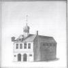
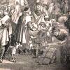
An ink-and-wash study of the Town Chamber, with Chapel to the rear, executed by Richard Powles in 1784. To be found in the Isaac Gillingwater collection of local illustrations c. 1807 - Suffolk Archives, Ipswich, 193/2/1.
, built in 1914 by Colby Bros. Ltd. on the southern side of Lowestoft’s inner harbour.")
Superstition and the Fisherman (c. 1910-1960)
The collection of superstitions which follows is not seen, in any way, as definitive. It simply records a number of the more commonly held beliefs once current in East Anglian fishing communities. Not all of them were peculiar to fishermen only; some had (and may still have) currency among seafarers in general, while others can be traced well inland. But no matter how extensive their area of circulation, all of them are interesting for what they tell us of the human mind and the way it works when faced with natural powers beyond either its understanding or its control.
Recorded Illegitimacy in Lowestoft (1561-1730)
The one thing missing from F.A. Crisp’s printed versions of the Lowestoft Parish Registers (1902) is any reference to the baptisms or burials of any infants born out of wedlock. Yet, such entries are there from the very first year of the first surviving register book: 1561. The best guess as to why this is so is probably to be found in attitudes of the time regarding illegitimacy being widely seen as a social disgrace, together with the more practical matter of who was to be responsible for the raising of the child – if it survived.

Relief of Distress in Other Communities (1681-1698)
Late 17th Century Public Collections Taken in Lowestoft
Sorting Out the Sinners in the 17th Century (Diocesan Visitations 1606-39)
Ecclesiastical Visitation Material (1606, 1629 & 1633)
Before the Diocese of St. Edmundsbury & Ipswich was created in 1914, Norwich Diocese was one of the largest in England – covering most of Norfolk and Suffolk (with small areas of the western margins of both counties coming under the Ely jurisdiction). Suffolk was divided into two Archdeaconaries: that of Sudbury covering the western half of the county and that of Suffolk covering the east.

Sinking of the Armed Smack Nelson (LT 649) – 15 August 1917
(LT 649)
If upon your port is seen
A little German submarine,
Do not fire shot nor shell.
Just turn around and run like hell!
(Fishermen’s parody of a navigation rhyme)

Ship Money Levy (1636)
So-called “Ship Money” had its roots in Late Medieval times, when coastal towns and counties in England were periodically called upon to supply vessels to the Crown for use in naval warfare during times of conflict – mainly with the French. After having suspended Parliament in 1629, following a series of disputes, and not reconvening it again until 1640, Charles I had to find ways of creating revenue other than the rents yielded by the Royal Estate.

The Day That Cromwell Came to Town (14 March 1643/4)
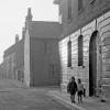
The top end of Rant Score – with the road still bearing the name of a family which held all the land between what is now 80 High Street and the score itself, from the end of the 16th century until the middle of the 17th. Looking at both road signs, at the top - with the smaller blue one advising motorists to “Beware oncoming Cyclists” - it is hard to imagine how cars going down the slope would ever be met by cyclists “tanking up” that gradient at any real turn of speed!

Samuel Morton Peto and the Wider European World (1830-60)
Centuries of Ongoing Change
Denmark Road, Flensburgh Street and Tonning Street: three closely connected roads near the shopping-centre and railway station of the Suffolk coastal town of Lowestoft (the UK’s most easterly community). What possible connection can there be between this trio, the most southerly located of the Scandinavian countries and two towns in the German state of Schleswig-Holstein?
. Image to be found in Edmund Gillingwater’s history of the town, p. 299.")
Lowestoft Schools (1570-1730)
Annot’s Free Grammar School
The single most important event in the process of public education in Lowestoft during the early modern period came in June 1570, when Thomas Annot (merchant) founded a free grammar school. A summary of the original deed of gift is to be found in the Rev. John Arrow’s Memorandum Book (he was Lowestoft’s parish priest, 1760-89) – Norfolk Record Office - PD 589/92, pp. 13-14. And it is also present in Edmund Gillingwater’s An Historical Account of the Ancient Town of Lowestoft (1790), p. 299.
. An aisled structure, re-roofed during the second half of the 19th century and with cross-wing added at the front, its ground-floor framing was thought to date from c. 1500. Radio-carbon dating, using samples from five of the individual timbers, showed that the oak was felled during the winter of 1609-10. The building once served as the parish tithe barn")
Lowestoft Agriculture (17th & 18th Century)
Grain
The potential value of Tithe Accounts books as a source of information regarding historical agricultural practice has long been recognised. The surviving Lowestoft tithe records (Norfolk Record Office, PD 589/80) begin to record details of agriculture in the parish in the year 1698, but there is no reference to the growing of corn until 1749 – the year in which the Rev. John Tanner began to draw the rectorial tithes.

Lothingland Invasion Scare (1584)
A constant matter of concern during the reign of Henry VIII (1509-47) was that of foreign invasion - particularly by France with the aid of its ally, Scotland. In 1535, a national audit of England’s defensive ability against foreign aggression was ordered by Henry VIII. With there being no regular Army of any kind at the time, lists had to be made of adult males able to fight in all areas of the country – and it was all done, hundred by hundred, to total up the numbers for every shire.

Lowestoft Timeline (c. 700,000 BC/BCE – 1524-5)
700,000 years ago - Early humans (hominids) present, using flint tools in what is now Pakefield. These anthropoids long pre-dated Homo neanderthalensis and Homo sapiens. The cores and flakes found date from roughly halfway through the Lower Palaeolithic age, which stretches from c. 1.5 million to 200,000 years ago.
Markets and Fairs in Lothingland & Lowestoft (1208-1703)
Lothingland
The original grant of a market in Lothingland Half-hundred was made by King John in the year 1211 – three years after Great Yarmouth had received its charter of incorporation (March 1208) with specifically stated preferential trading rights in its own local area. With Crown income solely in mind, the monarch either had no idea of the contention and strife these opposing privileges would cause or was not concerned about them in any way.

Relocation of the Township (c. 1300-1350)
Reasons for the move
It is perhaps unwise to single out any one particular event in the life of a community over a period of about 1,500 years as being the crucial or formative one (other than its founding), but there is a good case for doing so where Lowestoft is concerned.
, founder of the town’s free grammar school in 1570. Described in the 1545 Rental as a messuage and fish-house, with the building-plot then stretching from the High Street down to Whapload Road")
Lowestoft Rental (1545)
Lowestoft Rental (1545) – Suffolk Archives, Ipswich 194/A10/71
(Formerly North Suffolk Record Office, Lowestoft)
A Lowestoft rental renewed there on the first day of June, in the thirty-seventh year of the reign of our Lord King Henry VIII, by the grace of God King of England, France and Ireland, Defender of the Faith in the said land(s) and Supreme Head of the Church of England and Ireland – relating to the annual rents of the town of Lowestoft, Shadingfield, Ellough and Willingham. [Translated from Latin]
 - a merchant recently arrived in Lowestoft from Southwold, whose main business interests were in fishing and fish-curing.")
Lowestoft Overseers of the Poor Accounts (1656-1712)
The largest administrative task by far to demand both the attention and the time of the parochial authorities in Lowestoft during the Early Modern period was relief of the poor – a weighty responsibility placed upon English parishes by the formative Poor Law Act of 1601. And the fortunate survival of Overseers of the Poor account books for the period 1656-1712 (Suffolk Archives, Ipswich - 01/13/1/1&2) reveals much about the implementation of this legislation.
 - this area being the surviving remnant of the Goose Green/Fair Green area referred to in text, once smallest of the town’s seven areas of common land")
Lowestoft Manorial Governance (c. 1580-1730)
Serious crime, or felony (consisting of treason, murder, assault resulting in serious injury, witchcraft, highway robbery, arson, burglary, rape, grand arceny, forgery, counterfeiting and smuggling) was largely dealt with during the Early Modern period at the six-monthly assizes, held usually in the county towns of the realm. Though some of the offences named, if deemed to have been of a lesser level of seriousness (mainly, matters of assault – including rape – and damage to property), were handled at the three-monthly quarter sessions.
 advertised the “Queen’s Head” premises, halfway down Tyler’s Lane (Compass Street) on the south side. Taken from the Isaac Gillingwater collection of illustrations (c. 1807): Suffolk Archives (Ipswich), 192/3/1.")
Lowestoft Inns and Shops (16th-18th Century)
Inns
The configuration of roads and the importance of land transport have always been major influences on the development of towns and their inns. Large yards were necessary for stabling horses, and for standing carts and carriages; buildings were required for storing hay and other forage; and provision had to be made for watering the animals. Adequate accommodation was also needed for those people making overnight stops or staying in a place for longer.

Literacy Rates in Lowestoft (1560-1730)
Among the many interesting features to emerge from close study of the 507 wills and 100 probate inventories which have survived for the period indicated in the title are the rates of literacy able to be determined in the various occupational groups which formed the town’s socio-economic structure. Even today, there would probably be argument (or at least discussion) among specialists in the field as to what literacy means. The same holds true for historians.
.")
Land-use in Lowestoft Parish – 17th & 18th Century
It is unarguable that maritime influences were the major factor in shaping Lowestoft during the Late Medieval and Early Modern periods. Yet, agriculture was also an important element in the development of the town, creating employment for a number of the inhabitants (and limited wealth for a few) and leading to a number of associated trades and occupations. It also acted as a safety-net for the community, something that was always there as part of the economic structure – something that could, in periods of adversity, provide subsistence until better times returned.
")
Bequests for the Relief of Poverty, 1560-1730
For centuries, the use of alms boxes in parish churches throughout the whole of England was a means of collecting sums of money for charitable purposes – particularly the relief of poverty where it was known or seen to exist. During the 16th century, as a result of general cost inflation (aggravated by Henry VIII’s mindless extravagance and debasement of the coinage, to say nothing of the social and economic problems caused by the Dissolution of the Monasteries), the alleviation of financial distress in the lower levels of society became more and more of a challenge.
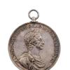
Battle of Lowestoft Medallion (1665)
On Tuesday 23 April, 2024, a silver medallion commemorating the naval victory of the English fleet over that of the United Provinces of the Netherlands during the Second Dutch War (1665-67) was offered for sale at an auction staged by Charles Millar of Fulham, specialists in maritime and scientific models, instruments and fine art. It fetched the sum of £550, plus seller’s and buyer’s commission.

A Seaside Excursion (1797)
Introduction
An account of this trip, taken by two young men, from Saffron Walden to Lowestoft and back, took place between Saturday 26 August and Sunday 3 September 1797. It is written on two pieces of rag-paper 7½ inches by 63/8 in size (190mm X 162), folded to form eight pages, and with a half-piece serving as the first two – the outer one of which is the title-page itself. Originally hand-stitched down the middle of the fold (and with this either failing or being removed, at some point), the document was later secured by a single staple in the middle.
Inventory of James Wilde (1684) – Probate Record
(14 March 1684)
An Inventory Indented of all and singular the goods and Chattels of James Wilde late of Lowestoft in the County of Suff[olk], merchant, valued and appraised the Fourteenth day of March in the year of our Lord One Thousand six hundred eighty three by Joshua Smithson, Nicholas Utting, Robert [? ] and John Aldred of Lowestoft aforesaid, Merchants, as Followeth

A Notable Rescue at Sea (1785)
Saved by the Argus
One of the earliest balloon flights in England took place on Saturday, 23 July 1785, at 4.25 p.m. in Quantrell’s Gardens, Norwich – located in the city adjacent to present-day Queen’s Road (part of the A147) in the area now occupied by a large Sainsbury supermarket.

A Short-lived Parish Workhouse (1739)
Robert Reeve (local lawyer), who lived at what is now No. 49 High Street and who had his office next door at No. 48, was steward of the Lowestoft manor during the late 18th and early 19th century. Among the many things he did, connected with the history of the town (and also with that of Lothingland Half-hundred) was to compile a four-volume, handwritten account of various aspects of their past, connected with manorial and parochial matters of all kinds. Dated at c.

Historical Account of the Denes (14th-18th Century)
The term denes is an earlier version of dunes. It derives from OE dūn, meaning “a hill”, and became applied to coastal sandhills during the late medieval period – being first identified in a printed source dating from the year 1523. In Lowestoft’s case, any undulating effect may never have been very great as a result of tidal action and the effect of the wind, and the progressive development of scrub-growth of one kind and another would have moderated this even further.

Inventory of Roger Hill (1588) – Probate Record
Roger Hill was a Lowestoft merchant of the second half of the sixteenth century, whose burial was recorded in the parish registers on 13 September 1588. He had made his will (Norfolk Record Office, 296 Homes) on 20 August and the inventory of his possessions (NRO INV 4/45) was taken on 16 September. He lived in what is now 31-32 High Street (not at No. 30, as I wrote in error in the LA&LHS Annual Report No.
.")
An Unexpected Royal visit (1737)
On 15 January 1737 – the year being 1736, by use of the old Julian Calendar – King George II (1683-1760) made a sudden and unplanned landing at Lowestoft, on a return journey from the North-western German province of Hanover – where he and his father, George I, were the rulers (as Electors) as well as being monarchs of Great Britain. Both of them made summer journeys, periodically, to spend time in their land of origin, and it was on his return from one of these that George II was forced to put ashore.

Apprenticing of Poor Children (1699-1730)
The details which follow are presented as closely as possible to how they appear in the Lowestoft Settlement and Apprenticeship Book: Suffolk Archives, Ipswich - 01/13/1/3. But, it has not been possible to replicate completely an identical layout of the document. Original spelling has been maintained and use made of square brackets to provide extra information and clarify matters where needed. Mauve-coloured highlighting is intended to make the individual years and other dates immediately visible.
 has the Gurneys, Birkbecks, Barclay and Buxton Bank located there, under the management of Henry Leman")
Before There Were Banks (Credit Provision 1585-1730)
Provision of credit in the community
The importance of scriveners as community bankers in London during the second half of the 17th century has been noted, as has their role as providers of funds elsewhere. Nor has the function of the goldsmith escaped attention. Lowestoft, being a town of modest size, had few named scriveners among its inhabitants (no more than six or seven have been identified between 1560 and 1730) and most of them had other occupations.

Brewing in Lowestoft (1560-1760)
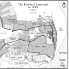
The Town of Lowestoft c. 1720
This map was created by Ivan Bunn (former archival assistant at the North Suffolk Record Office, Lowestoft) and the writer, working in collaboration and using manorial documentation as the primary source. See end of text for numbered locations, which are also referred to in the narrative.
, executed by Richard Powles in 1782. This was the town’s multi-purpose civic HQ until the Town Hall was built (1857-60), with the curfew bell hung in the cupola surmounting the roof. Suffolk Archives (Ipswich), 193/2/1 - the Isaac Gillingwater collection of illustrations (c. 1807).")
Churchwarden Accounts (1714-36)
The pages reproduced below, in as near as possible their original format, are to be found in volume 3, section 4, of Robert Reeve’s four volume manuscript ‘A History of Lowestoft and Lothingland’ (c. 1810) – Suffolk Archives (Ipswich), 193/3/4. Nothing is recorded for the years 1719, 1722, 1728 and 1733. Reeve (a local solicitor), who lived at No. 49 High Street, was steward of the manor and he must have transcribed this material from an original source of some kind.
Compass Street (14th-19th century)
Compass Street originally formed one track with Dove Street - known as Bier Lane during the 14th century, because it was the track by which corpses (placed on a hand-bier) were taken from town for burial in St. Margaret’s churchyard. The track extended westwards over Church Green, more or less following the line of what became - much later on - Wesley Street and Church Road. During the 16th and 17th century, the named changed to both Fair(stead) Lane and Almshouse Lane, since the annual fairs were held on Fair Green (which is the St.

Death on the Denes (1666)
Some idea of the vulnerability of the Lothingland coastline during times of trouble may be had from an incident which occurred during the Second Dutch War (1665-67). The Lowestoft parish registers have this entry, made on 7 February 1666 [1665, in the old-style calendar]: “Maijer Thomas Willd of Yarmouth, was kild at Corton by a musket shot that went into wessan”. The grave-slab of this man is set into the floor of the middle aisle of St. Margaret’s Church, not far from the chancel screen and next to that of his parents, John and Mary Wild(e).

Dickens, Lowestoft and David Copperfield (1849)
The Novel David Copperfield is well known for its central figure’s connection with Blundeston, Great Yarmouth and the Peggotty family – but, scarcely known at all for David’s brief acquaintance with the town of Lowestoft, as revealed in Chapter 2 of the novel.