
modern


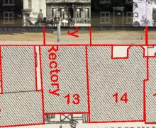
It is hard to make sense of the lost buildings at the top of High Street when all that is left is a long stretch of grass. So we started with an 1893 map that had TWO buildings that are STILL here today Arnold House (4) and The Flint House (now called The Royal Falcon (26)).
Added: 10 November, 2023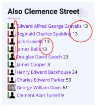
As part of our tribute to those Lowestoft people who died because of two World Wars. We came across 13 Clemence Street - perhaps the most unfortunate wartime address in Lowestoft?
Added: 10 October, 2023
A Millenium Heritage project from 1999 has been restored and saved by LO&N. It can be viewed here and even has its audio files updated to a current (playable) mp3 format as can be seen/heard here
Added: 6 October, 2023
Lowestoft’s worst raid of world war II 80 years ago today on 23 January 1942, while convoys of lorries were still trucking the wreckage and rubble from the scene of devastation that became known as "The Waller's raid" in London Road North, Lowestoft, another deadly raid occurred. An alert had been sounded at 8.41 am, probably caused by German bombers seeking a convoy in the North Sea. Barely a minute had elapsed after the warning when a lone bomber, variously identified as as a Do 217 or Ju 88 emerged from the snow clouds overhead and dived towards the railway station from the NE.
Added: 23 September, 2023
Coastal erosion (South beach, Lowestoft) 1906-2023 approx 200m! Measuring from the current cliff-top edge to the east of All Saints Church (as was) to the low-water mark on a OS 25-inch map, revised in 1903 and published in 1905. The lines in red are the old roads and buildings.
See also Dave Burt FB
Added: 23 September, 2023